TerrainCAD for AutoCAD 1.0
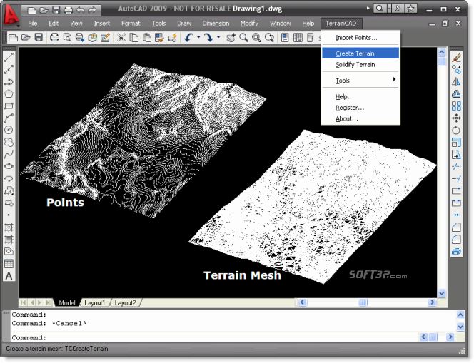
TerrainCAD for AutoCAD is a terrain modeling plug-in for AutoCAD®. This plug-in gives AutoCAD the ability to create a terrain mesh from a set of unordered points, lines and polylines. The terrain mesh is created as a Delaunay Triangulation.
Last update
10 Mar. 2009
Licence
Free to try |
$195.00
OS Support
Windows
Downloads
Total: 983 | Last week: 1
Ranking
#588 in
3D Modeling & CAD
Publisher
Sycode
Screenshots of TerrainCAD for AutoCAD

TerrainCAD for AutoCAD Publisher's Description
TerrainCAD for AutoCAD is a terrain modeling plug-in for AutoCAD®. This plug-in gives AutoCAD the ability to create a terrain mesh from a set of unordered points, lines and polylines. The terrain mesh is created as a Delaunay Triangulation, which is regarded as the best method to create a terrain mesh from unorganized point data. TerrainCAD for AutoCAD can also import a set of points from a text file containing point coordinate data along with point numbers and point descriptions. TerrainCAD for AutoCAD is powered by TerrainLib, a state of the art terrain modeling library developed by SYCODE.
TerrainCAD for AutoCAD is very easy to use. Once installed, it automatically loads itself into AutoCAD and adds a new submenu called "TerrainCAD" to the AutoCAD menu.
The 'TerrainCAD' menu consists of the following commands:
TCImportPoints - Import points from a text file
TCCreateTerrain - Create a mesh from a set of unordered points, lines and polylines
TCHelp - Displays the TerrainCAD for AutoCAD help file
TCRegister - Registers your copy of TerrainCAD for AutoCAD
TCAbout - Displays the TerrainCAD for AutoCAD about box
Look for Similar Items by Category
Feedback
- If you need help or have a question, contact us
- Would you like to update this product info?
- Is there any feedback you would like to provide? Click here
Popular Downloads
-
 Kundli
4.5
Kundli
4.5
-
 Macromedia Flash 8
8.0
Macromedia Flash 8
8.0
-
 Cool Edit Pro
2.1.3097.0
Cool Edit Pro
2.1.3097.0
-
 Hill Climb Racing
1.0
Hill Climb Racing
1.0
-
 Cheat Engine
6.8.1
Cheat Engine
6.8.1
-
 Grand Theft Auto: Vice City
1.0
Grand Theft Auto: Vice City
1.0
-
 C-Free
5.0
C-Free
5.0
-
 Windows XP Service Pack 3
Build...
Windows XP Service Pack 3
Build...
-
 Iggle Pop
1.0
Iggle Pop
1.0
-
 Grand Auto Adventure
1.0
Grand Auto Adventure
1.0
-
 Ulead Video Studio Plus
11
Ulead Video Studio Plus
11
-
 Netcut
2.1.4
Netcut
2.1.4
-
 Zuma Deluxe
1.0
Zuma Deluxe
1.0
-
 AtomTime Pro
3.1d
AtomTime Pro
3.1d
-
 Tom VPN
2.2.8
Tom VPN
2.2.8
-
 Minecraft
1.10.2
Minecraft
1.10.2
-
 Horizon
2.9.0.0
Horizon
2.9.0.0
-
 Vidnoz AI
1.0.0
Vidnoz AI
1.0.0
-
 Auto-Tune Evo VST
6.0.9.2
Auto-Tune Evo VST
6.0.9.2
-
 Vector on PC
1.0
Vector on PC
1.0